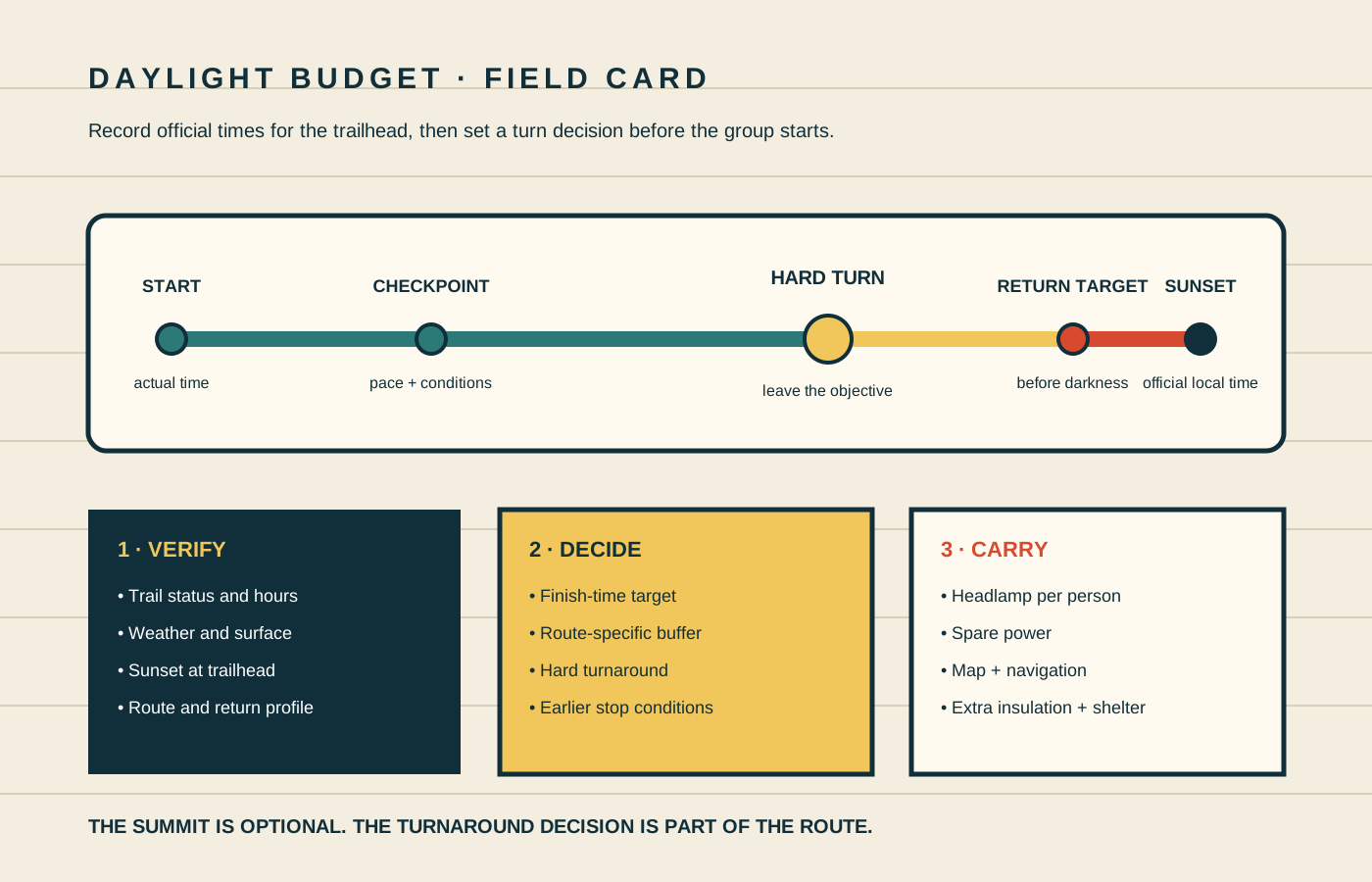
A winter day hike can begin under a bright sky and end in cold shadow. The useful planning question is not “Can we reach the viewpoint?” It is “What must be true at each checkpoint for the group to return on the intended route before darkness?”
National Park Service winter guidance highlights reduced daylight alongside precipitation and wind as a factor that affects a trip. Yosemite's Half Dome guidance makes the decision concrete: check sunrise and sunset, leave early, and use a non-negotiable turnaround time. The exact clock time belongs to the route and day, but the discipline transfers to any day hike.
Plan to finish before darkness when the route and local guidance call for it. Carry a working headlamp and spare power for each person anyway. Great Smoky Mountains National Park advises avoiding hiking after dark and says a phone light does not count as reliable illumination.
Build the budget backward
Start at the desired trailhead return time and work backward. That keeps the return leg visible while the group is still tempted by the objective. Do not start with sunset and simply divide the hours in half. An out-and-back route may descend on the way out and climb on the way back; ice may build in shaded sections; a loop may place its hardest navigation late in the day.
- Choose the return target. Set the time the group plans to be back at the trailhead, before darkness and before any gate, shuttle, permit, or parking deadline.
- Estimate the return leg. Use the slowest sustainable group pace on the actual return profile, current trail surface, elevation change, crossings, and navigation complexity.
- Add a route-specific delay buffer. Account for likely stops, traction changes, wayfinding checks, congestion, and the consequences of a minor incident. There is no universal number.
- Set the hard turnaround. Subtract the return estimate and delay buffer from the return target. This is the latest time to leave the objective area, even if the objective is close.
- Add earlier checkpoints. Pick mapped junctions or elapsed-time checks that reveal a pace problem before the hard turn.
Write the result in clock time, not only “turn around after three hours.” Clock time makes it easier to compare the plan with changing forecasts, an official sunset, a gate closure, and a message left with an emergency contact.
Verify sunset for the trailhead
Use an authoritative sunrise and sunset source for the trip date and location. The U.S. Naval Observatory provides a one-day sun and moon data service by location. Check the place, date, time zone, and daylight-saving status. A time copied for a nearby city can be a useful reasonableness check, but mountains, canyon walls, forest, and slope aspect may remove useful light from the trail earlier than the published astronomical sunset.
Record three separate ideas:
Official sunset
The published astronomical event for the selected location and date. Verify the time zone.
Local light loss
The earlier point when terrain or tree cover puts critical trail sections into shadow.
Return target
The group's planned trailhead arrival before darkness, with route-specific margin.
Hard turnaround
The latest departure from the outbound objective that preserves the return plan.
Sunset is not a promise of full visibility until that minute. A north-facing drainage can darken well before an open ridge. Overcast, snowfall, fog, smoke, and blowing snow can reduce visibility sooner. The planner should identify the section where light matters most—an icy descent, water crossing, unsigned junction, avalanche exposure, or rough footing—and schedule that section conservatively.
Estimate the return, not an ideal pace
Published trail duration is a starting estimate. It may describe dry conditions, a typical visitor, or the whole route without explaining stops. Winter surfaces can change the work dramatically. NPS winter guidance notes that snow-covered or icy trails are harder, and Bryce Canyon warns that packed winter trails can become icy enough to require traction.
Build the return estimate from evidence the group actually has:
- a recent time on similar distance, elevation, and surface;
- the pace of the slowest group member while still warm, fed, and moving comfortably;
- time to add or remove traction and layers;
- navigation stops at junctions or obscured trail sections;
- breaks, water, food, and medication needs;
- the direction of elevation change on the return;
- conditions likely after the sun leaves the slope.
Do not plan around a best day. If the route estimate only works when every person moves faster than their verified pace and no delay occurs, choose a shorter objective. The NPS advises hikers to know their limits and avoid hiking beyond a safe distance. Turning a long loop into a short out-and-back often gives the group more control over the remaining distance.
Why the halfway rule fails
Turning when half the daylight is gone assumes both legs take the same time and have the same risk. That is often false. A return that climbs, crosses an exposed ridge, requires more navigation, or occurs on refrozen snow needs more time. Conversely, a simple return may be faster, but that does not justify spending the entire difference. Use the route profile rather than a slogan.
Make the turnaround hard and the stop conditions earlier
A hard turnaround is a decision made before summit fever, group pressure, or “just ten more minutes” changes the standard. Record it on the map or trip card and tell the whole group. Reaching the objective after that time is not success; it means the return plan has already been spent.
Conditions can require turning sooner. Define those stop conditions beside the clock:
- the group reaches a checkpoint later than planned;
- pace drops while the remaining return estimate grows;
- wind, snow, rain, fog, or visibility worsens beyond the trip plan;
- traction is inadequate for the surface ahead or the return descent;
- a person becomes unusually cold, wet, fatigued, confused, unsteady, or unable to eat and drink normally;
- location confidence falls or navigation tools disagree;
- the route, road, facility, or gate status differs from the verified plan.
Cold-related judgment problems make early decisions valuable. The site's cold-rain hypothermia guide explains why confusion, clumsiness, and altered behavior are not conditions for extending the day. If location confidence is lost, use the STOP and last-known-location process rather than forcing downhill movement.
Update the schedule at checkpoints
A plan written at home must meet the actual trail. Use mapped, unmistakable checkpoints or timed checks. At each one, compare actual time, position, weather, surface, group condition, and remaining return duration. The question is not “Are we having fun?” but “Does the original return plan still hold with what we now know?”
- Confirm location. Identify the junction, landmark, or coordinates using more than wishful matching.
- Read the clock. Compare actual arrival with the planned checkpoint time.
- Re-estimate the return. Use the pace observed so far and the terrain still ahead in both directions.
- Check the group. Ask each person directly about cold, feet, food, water, fatigue, medication, and confidence.
- Check the environment. Revisit weather, wind, visibility, snow, ice, water, and any closure information available.
- Decide once. Continue only if the return target and all stop conditions still work. Otherwise turn around.
Do not trade multiple small margins at once. A ten-minute late start, fifteen-minute equipment delay, slower snow, and an extended photo stop can consume an hour without any single dramatic event. The written checkpoints expose that drift.
Leave a trip plan that matches the clock
NPS guidance recommends filing an itinerary with a trusted person. Give that contact the route, trailhead, vehicle details, group, equipment or communication limits, planned start, turnaround, expected return, and the specific time and process for seeking help if you do not check in. Tell them when the plan changes; an unused plan with an old route wastes time.
Cell coverage is not assured. A phone can support navigation and communication, but the plan should still include a map, compass or other appropriate navigation tools, and the skill to use them. The declination guide provides a controlled practice workflow before relying on a map-and-compass route.
Carry backup light and test it
NPS lists illumination among the Ten Essentials and recommends a headlamp or flashlight with extra batteries. Give every person an independent light; one lamp at the front does not help if the group separates or the device fails. Check operation before leaving home and again at the trailhead.
Cold can reduce battery performance. Follow the light and battery manufacturers' temperature, charging, transport, and storage instructions. Protect spare batteries from short circuits and moisture. Know how the controls work while wearing gloves, and prevent the lamp from switching on inside the pack.
A phone flashlight shares power with navigation and emergency communication, is awkward for hands-free movement, and can fail after a drop or cold-soaked battery. Treat it as an additional tool, not the group's planned illumination. If the trip intentionally includes darkness, that is a different activity requiring route-specific rules, skills, legal access, and practice; do not let an accidental overrun become an improvised night hike.
Choose the shorter plan when the margins are thin
Winter route planning is not an optimization contest. A shorter route can preserve daylight for careful footing, layer changes, navigation checks, and an unhurried return. It can also create time to practice one skill well. The useful outcome is a group that returns with enough capacity to describe what worked and update the next plan.
Practice: a 25-minute daylight budget
Do this at home or at a familiar, permitted local path. Do not practice by deliberately finishing after dark.
- Choose a real date, trailhead, and short route with a clear map.
- Record official sunset, time zone, park hours, current alerts, and weather source.
- Choose a trailhead return target before darkness and explain the margin.
- Estimate the return leg using the slowest group pace and actual return profile.
- Subtract the delay buffer and write a hard turnaround clock time.
- Add two early checkpoints with specific continue-or-turn questions.
- Test every headlamp, spare power source, and map access.
- Give the plan to a partner and ask them to identify one hidden assumption.
Frequently asked questions
How do I choose a winter hiking turnaround time?
Set a desired trailhead return time before darkness. Subtract the expected return duration for the route, surface, and slowest group pace, then subtract a route-specific delay buffer. Add earlier checkpoints and turn sooner if conditions or pace no longer support the plan.
Is halfway to sunset always the right turnaround?
No. It assumes the two directions are equally fast and difficult. Use the actual return elevation, surface, navigation, and group pace. A return climb or icy descent can take longer than the outbound leg.
Do I need a headlamp if I plan to finish before sunset?
Yes. NPS includes illumination among the Ten Essentials. Carry a working headlamp or flashlight with extra batteries for each person, while still planning the route to meet the intended daylight return.
What if we are close to the summit at the hard turnaround?
Turn around. The clock was set before the group could see the objective precisely to protect the return plan from that pressure. Reaching a summit does not restore daylight or remove the terrain already behind you.
Sources checked
Reviewed October 21, 2026.
- National Park Service — Be Winter Ready for Your Adventure
- Yosemite National Park — Half Dome Day Hike
- National Park Service — About Hiking Safety
- Great Smoky Mountains National Park — Hiking Safety
- Guadalupe Mountains National Park — Day Hike Preparation
- National Park Service — Ten Essentials
- U.S. Naval Observatory — Complete Sun and Moon Data for One Day